The Switchback Trail -- Summit Hill Walker's Tours
| Due to changes in conditions, use of this information is at the sole risk of the user. |
 |
| Map copyright © 1997 by Switchback Gravity Railroad Foundation, Inc. |
The tours of the western end of the Switchback route are combined driving and walking tours with four sites to explore and an automobile ride down part of the Switchback route.
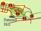
 The Mt. Jefferson Plane Base Exploration begins with a car stop on the Lentz Trail highway just east of the intersection with State Route 902. A gravel parking area marks the remains of the base of the Mt. Jefferson Plane,9. (Today, a telephone line ascends the plane.)
-
- The Mt. Jefferson Engine House Exploration is the logical continuation of a visit to the base of the plane. Proceed by car north on Route 902 to the top of the hill (now Pine Street in Summit Hill). At the intersection 11 with Ludlow Street, turn right (east) and proceed to the eastern limits of the cemetery on the south side of the street. Park and proceed on foot to the site of the Mt. Jefferson Engine House 10 at the top of the plane. There are some concrete slabs on the site, but nothing else remains of this engine house.
-
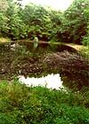
- Water for the stationary steam engine housed here was provided from the so-called Spring Cistern located down the hill below the point where the Down Track crossed under the ascending Mt. Jefferson Plane. Water was pumped up the hill to a pond near the engine house.
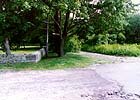
- The Pine Street Overpass Exploration involves a stop on the way into town from the Mt. Jefferson Engine House site. Back tracking on foot and by car, follow the Summit Hill arrival route of the Switchback west on Ludlow Street to the intersection with Pine Street, the site of the Pine Street Overpass 11. The stones here mark the original abutment. The surviving locally-quarried stones supported the overpass.
-
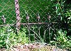
- The Summit Hill Depot Exploration is an exploration of the site of the Summit Hill Switchback Depot. Proceed by car or foot west to the site of the depot 12, now occupied by a legal office and the Vermillion Professional Building. Look carefully in the vacant area to the east of the single-story building which is to the east of the Vermillion Building. Projecting from the ground is the top foot of a wrought iron fence which remains from the days of the Switchback. The fence followed the inside of the track roadbed as it curved toward the southwest behind the depot.
-
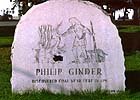
- The Ride To Stoney Lonesome is an enjoyable coasting trip down the start of the route of the original 1827 Down Track. Although it is certainly a pleasant walk, it is perhaps more enjoyable by car. From the site of the Summit Hill Depot 12, trace the first part of the route of the Down Track as it returns to Mauch Chunk. Proceed from Ludlow Street, around the street on the eastern side of the park. (There is a monument commemorating Philip Ginter's discovery of coal on the western side of the park.) Then, turn east onto Holland Street. Continue on Holland Street, crossing through the intersection with Route 902 (Pine Street). Once through the stop sign at that intersection, let your vehicle coast down the original Back Track route to the site of the Mt. Jefferson Underpass, 13.
- A pier that supported a water supply pipe remains on the north side of the road a few hundred feet east of the overpass. The pipe supplied water to the Mt. Jefferson Engine House from the Spring Cistern located down the hill to the south.
- After exploring the area of the overpass stonework, continue coasting east on the Down Track route until the road ends in a settled area. This is the end of the tour, and, if driving, the route must be retraced back to Summit Hill.
 Return to the Trail Map.
 Return to Switchback Home Page.