| Due to changes in conditions, use of this information is at the sole risk of the user. |
 |
| Map copyright © 1997 by Switchback Gravity Railroad Foundation, Inc. |
| Due to changes in conditions, use of this information is at the sole risk of the user. |
|
| Map copyright © 1997 by Switchback Gravity Railroad Foundation, Inc. |
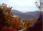
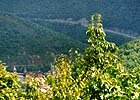
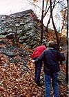
This tour is recommended only for experienced hikers with the capacity to handle a moderately steep climb and detour around potentially treacherous spots. There are two routes to the top of Mt. Pisgah, and there are debates about which is easier --
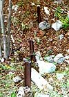

 The route of the plane up the east side of the mountain is evident when viewed from the site of the engine house. Some interesting artifacts here include a toppled metal smoke stack that characterized the engine house when in use and well-worn rails used to reinforce the concrete foundation. These re-used rails are among the oldest Switchback solid iron rails in existence.
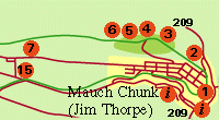
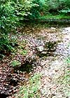
The relatively late vintage reservoir on the south side supplied the engine house boilers. The rubble in the same general area is what is left of the original reservoir. Water was piped from Indian Spring 6, across on the west side of the trestle.
 Moving to the west to the site of the trestle, 4, one finds piers remaining that once supported the trestle which spanned the slump between the peak to the east and the ridge to the west. The trestle bents were anchored to the concrete piers. It had to be a thrill when the trestle was first encountered immediately after a car drifted out of the engine house.
Continuing to the western side of the slump originally bridged by the trestle is the western abutment. A short distance after ascending it is the site of the Pavilion Station 5. The path that leads off the north side of the roadbed leads to the location of the Pavilion itself and its nearby observation tower. All three wooden structures had disappeared by 1890.
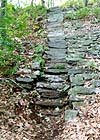
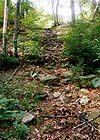
 Continue to the west along the roadbed to find a narrow rock stairway that leads up the steep rock bank on the north side to Indian Spring 6.
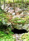

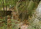 Proceed now on a pleasant downgrade hike to the site of the Hacklebernie 7 mining operation. The railroad roadbed traversed the ridge here on a short trestle that bridged a cave-in on the side of a rock face. Hikers should be cautious traversing the rock face here or should bypass the potentially hazardous area by descending the steep bank to the south and ascending it again to the west.
There are two options for return: retracing the path just hiked from Upper Mauch Chunk or continuing on to the Five Mile Tree 8 crossover and returning to Mauch Chunk via either the Home Stretch route or the Lentz Trail highway. In the latter case, when reaching the intersection marked by the White Bear Inn, follow the intersecting road into Upper Mauch Chunk or continue on Lentz Trail into downtown Mauch Chunk.
![]() Return to the Trail Map.
Return to the Trail Map.
![]() Return to Switchback Home Page.
Return to Switchback Home Page.